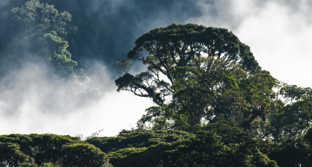
The Costa Rica volcanoes belong the continental territory is formed by a central longitudinal mountainous axis, closer to the coast of the Pacific Ocean, located in a northwest-southeast direction, approximately 650 km long. The northern part of Costa Rica is crossed by three volcanic mountain ranges, the Cordillera Volcánica de Guanacaste, the Cordillera de Tilarán, and the Cordillera Volcánica Central. The southern part is crossed by the Cordillera de Talamanca which was formed by uplifting forces rather than volcanic eruptions.
Costa Rica is home to a great number of volcanoes — there are six active volcanoes and another 61 dormant or extinct ones. For the past 50 years, Arenal was the country’s most active volcano. Nonetheless there are 112 volcanoes and 132 craters whom many had been cover by lush rainforests.
The following list completes the totality of the volcanoes that exist in Costa Rica that had shown recent (geological time) activity.
Aguas Zarcas
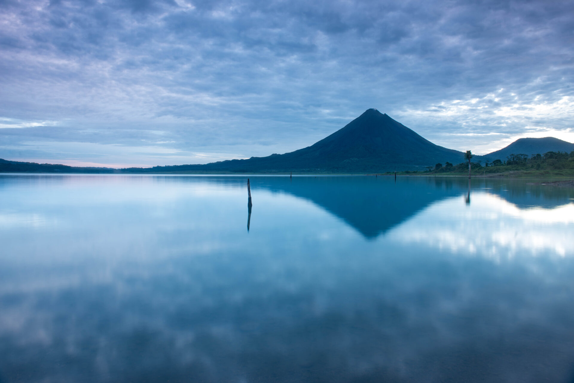
Arenal
Barva
Cacho Negro
Cerro Pelado
Cerro Plano
Chopo
Congo
Irazú
Laguna Hule (Bosque Alegre)
Río Cuarto Lagoon
Miravalles
Orosi
Pelado
Platanar
Poas
Pocosol
Porvenir
Cacao
Rincon de La Vieja
Tilaran
Tenorio
Tortuguero
Turrialba
El Viejo
Here is the list of 6 volcanoes to visit in Costa Rica.
Arenal
El Arenal held for more than forty years the status of being one of the sixteen most active volcanoes in the world, being located within the hundred best known volcanoes globally, and one of the most studied in Latin America. On a national scale, it is the volcano that has caused the most deaths (81 in total), the most dangerous, and the only one to emit lava
flows in historical times. It has been a natural laboratory on animal and plant colonization of the rugged rocky mantle, and even better on volcanic processes in open systems. The amount of lava emitted during these four decades of eruption exceeds half a cubic kilometer, material with which a road could be built that would circle the Earth four times.
One of the last periods of important activity occurred between February 23 and March 2, 2010; on May 24 there were pyroclastic flows. The Arenal activity, however, decreased in significant magnitude since July 2010 (42 years after its awakening) and in particular since October, and decreased in January 2011, where the latest advances in lava flows are reported, but without being clear whether or not they had a direct feed or if they were only the remnants of their last languages from December 2010. Since then, no incandescence has been reported again, related to explosions or the advance of lava flows, only gas outlet.
The current seismicity is low and no explosions were reported again.
The volcano came to rest as of January 2011. Its main danger today is landslides or a possible reactivation. The most frequent dangers during its recent eruptive period were volcanic projectiles ejected during explosions, lava flows, pyroclastic flows, and to a lesser extent, acid rain and lahars. In prehistoric eruptions, its dangers, in addition to the previous ones, have been mainly the Plinian and subplinian eruptions, with the ejection of large
quantities of explosive products (bombs and blocks, pumice lapilli and slag and ash), either ballistic projection, fall or as pyroclastic flows and waves. The formation of new craters and cones is always a possibility.
Where to go birding at Arenal:
The region offers some of the best intermountain valley birding in Costa Rica, with a large number of hotels, and infrastructure for the visitors such as Canopy Bridges, forested trails, national parks and reserves. Many back roads are also great birdwatching if you have a 4×4 or hire a local guide. Our recommendations due experience rather than tour gimmicks are: Arenal Observatory Lodge, Mistico Hanging Bridges, El Castillo Road, Former Eco Lodge or Malekus today (this it used to be the most amazing birding in Costa Rica for decades until the lodge was sold).
Irazu volcano
It is the highest volcano in Costa Rica. Its Caribbean flank is strongly eroded, with deep canyons, large landslides and a very abrupt and tectonized topography, although part of its original volcanic shield morphology is still preserved, with gently sloping lava platforms. Its flank, peaceful, where the city of Cartago sits, has a gentler slope. The main crater is almost circular in shape and houses a lagoon with a maximum diameter of about 235 m, between 10 and 30 m deep. To the east of this crater is another inactive crater called “Diego de la Haya Fernández”. To the south of these craters and separated by a volcanic terrace called Playa Hermosa, there are the remains of an old “calderic” rim. To the east of Diego de la Haya, there is a pyroclastic cone with a crater destroyed to the north and from which a lava flow is poured. This cone is embroidered on the east and south sides by the remains of two crateric structures. In the eastern sector, there are remains of an old cone, very eroded to the north. To the northeast of the main crater are lava flows, limited by faults. Towards the south of the main summit are the pyroclastic cones: the Noche Buena, Gurdián, Pasquí hills and the Dussan-Quemados group. On the southern slopes of the Irazú is the Cervantes lava field, one of the largest in Costa Rica.
Where to go birding at Irazu:
Sadly, most of the area has been develop on farms very little forest is left yet here some suggestions, Prusia Road has still some decent vegetative formations along, we had seen tons of good birds including Resplendent Quetzals. Also the road towards Turrialba Volcano offers some good back road birding.
Poas Volcano
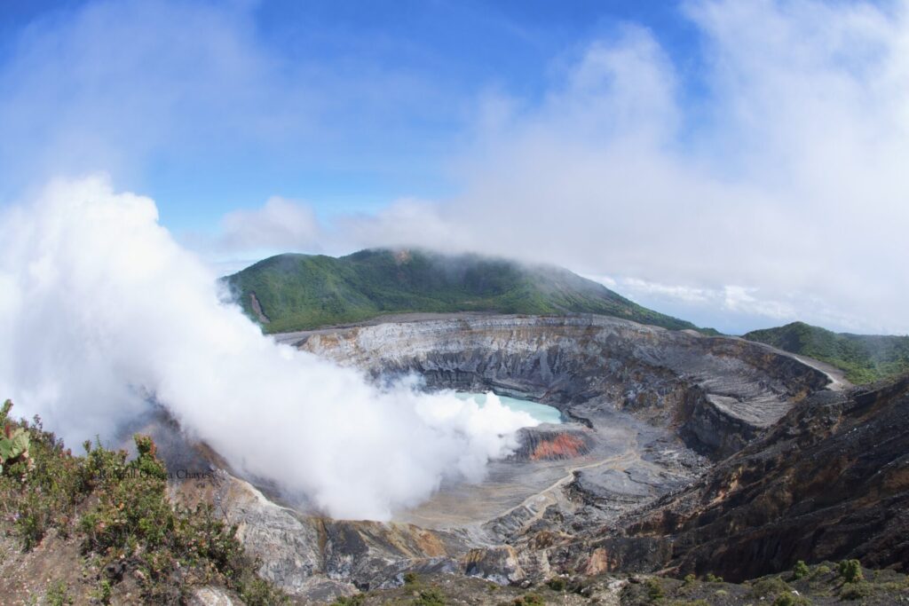
At the top are located the three most recent main structures: the main crater of Poás, the Botos or Fría lagoon and the Von Frantzius cone, all of them limited by faults, which make up a volcano-tectonic depression (graben). From the mid-1960s to April 2017, four morphogenetic units were distinguished within the main crater: an eastern plateau, a crater lagoon, a lava dome, and an internal beach. The dome, which was destroyed on the night of April 19, 2017, was located in the northern sector of the crater (30 m high) and was of subhemispheric morphology, affected by erosive processes and by eruptive activity. The walls of the main crater have steep slopes (subvertical in the northern part) also affected by erosion from rainwater runoff and landslides. The eastern plateau forms a vast volcanic
terrace, 500 m long.
On the western flank of the crater, the original volcanic morphology has been modified, currently generating structural forms as a result of the exhumation of the old emission conduits or chimneys, called volcanic dikes, which are in turn cut by faults.
In the surroundings of the crater abundant quantities of sulfur are present, either as microscopic particles or in large masses of crystalline aggregates, and older lacustrine sequences, indicating that thermo-mineral crater lagoons have been present for at least a millennium. The lavas in general are andesites and basaltic andesites and to a lesser extent dacites and basalts.
Where to go birding at Poas Volcano:
If you are an early riser then you are good to go.
Birding at Poas Volcano is very rewarding. Although the national park itself opens at 7:00 am to 1:00 pm; that goes to Votos Lagoon specially the one that most people avoid. Since its relative short time for a birder to stay at the park we suggest to visit the lower elevations near the entrance heavily forested road edges are awesome. Some of the common birds are Slaty Flowerpiercer, Sooty capped Bush Chlorospingus, Flame colored Tanager, Sooty Thrush, Volcano Hummingbird, Ruddy Treerunner, Long tailed Silkyflycatcher.
Turrialba volcano
It shares the same base as the Irazú volcano and is the easternmost volcano of the Central volcanic mountain range. Because its position is outside the general alignment of this mountain range, it belongs, together with the Cacho Negro, Congo and Platanar volcanoes, to another alignment of volcanoes parallel to the main axis of the central volcanic mountain range. The top of the Turrialba volcano is made up of a volcanic avalanche caldera within which are located the three main craters and others disfigured by past eruptive and erosive activity. In the same way, there are several older buildings or volcanic cones, such as the Dos Novillos volcano, and satellite pyroclastic cones such as the Tiendilla and Armado hills.
The flanks of the main massif are made up of relatively recent lava flows covered by layers of pyroclastic rocks of fall, flow and surge. These lavas are basaltic andesites, basalts, andesites with a high potassium content and few dacites. Structurally, there are several active faults that cut through the volcanic structure.
Where to go birding at Turrialba Volcano:
The real question is where not to!! Under similar situations with its Twin” volcanoe Irazu; where most of the land has been set to agriculture, your best bet to get some very rewarding birding is leaving your car by the main road next to the dairy farms or the actual small parking lot (they have a daily charge of $5) and then hike to the proper national park entrance. We would like you to know that is actually close still the forested edges are very good. Many of the birds sighted along the unpaved gravel road are similar to those found at Irazu and Poas but the big difference can reside on uncommon sightings such as Slaty Flowerpiercer, Barred Parakeets feeding on bushes (since there are no visitors); mixed flocks ranging from common Chlorospingus to Foliage gleaners or/and Unspotted Saw Whet Owl.
Rincon de la Vieja volcano
It is a stratovolcano of complex and irregular shape. Its summit is made up of at least nine eruptive foci that are still recognizable, although clearly its history corresponds to the superposition and destruction of several volcanic buildings over more than a million years. It is the largest volcanic center and the only active one in the Cordillera de Guanacaste.
The first volcanic structure was a low building with a possible crater, both destroyed by erosive agents. The second is a cone with a heavily eroded crater. The third is a cone (Braun hill) that has a crater open to the northwest and with a flat bottom, and the Von Seebach crater that is a remnant of that one. The fourth is a cone whose crater presents to the southwest of its interior a highly eroded volcanic terrace, and at the bottom to the northwest, a hot lagoon that constitutes an active crater.
The fifth is a well-built cone covered with vegetation, with a crater with a volcanic terrace to the south and a small lagoon to the north. This cone shows a small parasite on its northwest skirt. To the southwest and south of it are two hills that could be the remains of an ancient oval caldera. At the top of the massif there is a meteoric water dam lake.
Recent volcanic products (last 30,000 years) correspond to lavas and pyroclastic rocks of andesitic composition, with scarce basaltic andesites and dacites. The historical eruptions have been the richest in silica (50-60%), located 25 km from the city of Liberia, between the provinces of Alajuela and Guanacaste.
Where to go birding at Rincon de la Vieja:
Its rather an easy suggestion, if you are staying nearby or don’t know where to stay we consider Hacienda Guachipelin to be the best option for the following reasons: They own lots of land with a huge number of trails to spot great dry forest birds such as Thicket Tinamou, any of the forested trails to waterfalls and including just the road can offer you well over 100 species. Visiting the national park for
birdwatching is totally a must. Lesser ground Cuckoos, Great Tinamous, Royal Flycatcher, Long tailed Manakin, White throated Magpie Jay to mention few.
Tenorio Volcano
The 225 square km dominantly andesitic Tenorio volcanic massif anchors the SE end of the Guanacaste Range and consists of a cluster of densely forested NNW-SSE-trending volcanic cones. Overlapping lava flows from the principal peak, Tenorio, blanket the NW-to-SW flanks and descend the NE flank. The NW-most of three craters of the central cone is sparsely vegetated and appears to be the most recently active. Volcán Montezuma to the north has twin craters, the northern of which fed a lava flow to the NE. Additional pyroclastic cones are found to the NE and SW of the central complex, and the Bijagua lava domes were constructed on the northern flank. A major debris avalanche covered about 100 sq km below the southern flank of the volcano. A legend exists of an eruption in 1816, but the volcano was densely forested at the time of an 1864 visit by Seebach and is not considered to have erupted in historical time. Fumarolic activity is present on the NE flank.
It ranges from 90 to 1916 meters above sea level and protects well over 12800 hectares of rainforest and cloud forest on the upper peaks.
Where to go birding at Tenorio:
We don’t really encourage serious birders to visit the park for its birds but if you are also sightseeing go for it. Trails are not for everyone and high concentration of tourist can be a beat of a headache during the weekends (therefore avoid those days at all cost if you can). But we strongly suggest to visit Heliconias Lodge at Bijagua, they have the best birding trails out there with several suspended canopy bridges and well maintain loops that you can easily spend 3 days there. Also a most recent private forest known as Tapir Valley they claim a Tody Motmot is not a hard task at the premises.
At Heliconias Lodge what birds you should aspect? We must be extremely honest with you. IF you hit an army ants swarm and a mid-canopy mixed flock you could well say that is the absolute best birding in your life time. Species such as Black crested Coquette, Bare necked Umbrellabird, Rufous vented ground Cuckoo, Keel billed Motmot, Olive backed Quail Dove, Ocellated Antbird, Crested Eagle and even the all mighty Harpy Eaglevhas been most recently photographed nearby Tenorio in a small town call Birmania.
https://www.ecured.cu/Cordillera_Volcánica_Central_(Costa_Rica)
http://puravida.com/es/cordilleras-costa-rica/
https://es.wikipedia.org/wiki/Eje_monta%C3%B1oso_central_de_Costa_Rica
https://rsn.ucr.ac.cr/actividad-volcanica/volcanes-costa-rica